
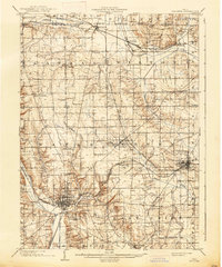
1903 Map of Akron
USGS Topo · Published 1961About this map
The Ohio and Erie Canal and the Cuyahoga River dominate the eastern corridor of this landscape, tracing a industrial and transit path through Peninsula and down into the growing city of Akron. At this turn-of-the-century moment, the region is a dense network of crossroads settlements and post offices like Ellis Corners Montrose PO and Bates Corners. To the north, the distinctive Boston Ledges and Ritchie Ledges define the terrain, while the canal's infrastructure is marked by specific landmarks such as Deep Lock and Pancake Lock.
Find a feature on this map
97 named features on this map. Tap any name to fly to it.
Don’t see what you’re looking for? This feature index may not catch every label — zoom into the map to look around manually.
Map Details
Editions of this 1903 Akron Map
This is the sole edition of this map. No revisions or reprints were ever made.
Other maps of this area

1901 · Massillon
USGS Topo · 1:62,500

1901 · Canton
USGS Topo · 1:62,500

1901 · Wooster
USGS Topo · 1:62,500

1902 · Berea
USGS Topo · 1:62,500

1903 · Massillon
USGS Topo · 1:62,500
1903 · Wooster
USGS Topo · 1:62,500

1903 · Cleveland
USGS Topo · 1:62,500

1903 · Canton
USGS Topo · 1:62,500

1904 · Berea
USGS Topo · 1:62,500
1904 · Medina
USGS Topo · 1:62,500