
1902 Map of Berea
USGS Topo · Published 1958About this map
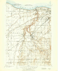
The Rocky River carves a deep, winding canyon through this landscape at the start of the 20th century, serving as a dramatic natural boundary between the expanding streetcar suburbs of Lakewood and the agricultural townships to the west. This survey captures a pivotal era of regional connectivity, dominated by an intricate web of steam and electric lines such as the Cleveland Electric R. R. and the Lake Shore and Michigan Southern R. R.. These rails fostered the growth of towns like Berea and Olmsted Falls, while the northern shoreline of Lake Erie shows early developments at Clifton Park and Avon Lake. Away from the rail corridors, the terrain is defined by a series of ancient glacial features including North Ridge, Middle Ridge, and Butternut Ridge, which historically dictated the path of local roads and early settlement patterns in Middleburg and Strongsville townships.
Find a feature on this map
80 named features on this map. Tap any name to fly to it.
Don’t see what you’re looking for? This feature index may not catch every label — zoom into the map to look around manually.
Map Details
Editions of this 1902 Berea Map
2 editions found
Other maps of this area

1901 · Oberlin
USGS Topo · 1:62,500

1901 · Euclid
USGS Topo · 1:62,500

1903 · Cleveland
USGS Topo · 1:62,500

1903 · Euclid
USGS Topo · 1:62,500

1903 · Oberlin
USGS Topo · 1:62,500

1903 · Akron
USGS Topo · 1:62,500

1904 · Berea
USGS Topo · 1:62,500

1904 · Medina
USGS Topo · 1:62,500

1904 · Wellington
USGS Topo · 1:62,500

1905 · Akron
USGS Topo · 1:62,500