
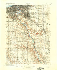
1903 Map of Cleveland
USGS Topo · Published 1939About this map
The Cuyahoga River carves a deep, winding path through this 1901 survey, illustrating the industrial and residential expansion of the region south of Lake Erie. The urban grid of Cleveland is densely established in the north, punctuated by significant public spaces like Edgewater Park and Forest City Park. As the terrain moves south into Independence and Brecksville, the landscape shifts toward steep ravines and creek valleys, where smaller settlements like Willow and Southpark follow the Cleveland and Terminal Valley R. R. line.
Find a feature on this map
68 named features on this map. Tap any name to fly to it.
Don’t see what you’re looking for? This feature index may not catch every label — zoom into the map to look around manually.
Map Details
Editions of this 1903 Cleveland Map
2 editions found
Other maps of this area

1901 · Euclid
USGS Topo · 1:62,500

1902 · Berea
USGS Topo · 1:62,500

1903 · Euclid
USGS Topo · 1:62,500

1903 · Akron
USGS Topo · 1:62,500

1904 · Berea
USGS Topo · 1:62,500

1904 · Medina
USGS Topo · 1:62,500

1905 · Akron
USGS Topo · 1:62,500

1905 · Mentor
USGS Topo · 1:62,500

1906 · Medina
USGS Topo · 1:62,500

1906 · Kent
USGS Topo · 1:62,500