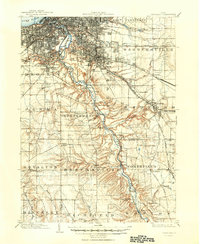
1903 Map of Cleveland
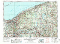
USGS Topo · Published 1950About this map
The Ohio and Erie Canal traces a parallel path with the Cuyahoga River through this turn-of-the-century landscape, illustrating the critical transportation infrastructure that shaped the region's industrial growth. This survey captures a dense network of steam and electric rail lines, such as the Cleveland Electric R. R. and the Pennsylvania R. R., radiating from the urban core toward outlying townships. While the northern edge shows the developing street grids of South Brooklyn and Warrensville, the southern portion remains largely rural, defined by smaller settlements like Walling Corners and Brandywine. The rugged terrain surrounding Tinkers Creek and Chippewa Creek provides a sharp contrast to the plateaued residential areas. Genealogists will find significant value in the detailed locations of large burial grounds, including Riverside Cemetery and Calvary Cem., alongside landmarks like Forest City Park.
Find a feature on this map
65 named features on this map. Tap any name to fly to it.
Don’t see what you’re looking for? This feature index may not catch every label — zoom into the map to look around manually.
Map Details
Editions of this 1903 Cleveland Map
2 editions found

Historical Maps of Cleveland Through Time
4 maps found