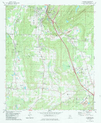
1980 Map of Alabaster
USGS Topo · Published 1984About this map
Alabaster and Siluria dominate the northern portion of this 1980 survey, where the Louisville and Nashville railroad corridor defines the industrial and residential spine of the region. The landscape transitions from the developed corridors of Elliotsville and Saginaw into the topographic variety of Opossum Valley and Pine Ridge to the west. A significant transportation and infrastructure hub is evident at the Shelby County Airport, while the eastern side of the quadrangle is marked by the rugged heights of Double Mountain and Locust Ridge. Family history is preserved through numerous community anchors, including Benton Cem, Nabors Cem, and Still Memorial Cem. The map captures a moment of growth just before further suburbanization, documenting smaller settlements like Dogwood and Underwood alongside institutional landmarks such as Shelby Academy and the local Drive-in Theater.
Find a feature on this map
57 named features on this map. Tap any name to fly to it.
Don’t see what you’re looking for? This feature index may not catch every label — zoom into the map to look around manually.
Map Details
Editions of this 1980 Alabaster Map
3 editions found
Other maps of this area

1890 · Bessemer
USGS Topo · 1:125,000

1892 · Bessemer
USGS Topo · 1:125,000

1905 · Bessemer Iron District
USGS Topo · 1:62,500

1906 · Vandiver
USGS Topo · 1:62,500

1907 · Bessemer Special
USGS Topo · 1:62,500

1908 · Vandiver
USGS Topo · 1:62,500

1909 · Columbiana
USGS Topo · 1:62,500

1910 · Montevallo
USGS Topo · 1:62,500

1911 · Columbiana
USGS Topo · 1:62,500

1953 · Birmingham
USGS Topo · 1:250,000