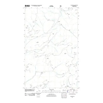
2011 Map of Aladdin
USGS Topo · Published 2011About this map
Aladdin serves as the central focal point of this Stevens County survey, situated along the primary corridor of Aladdin Rd. The landscape is defined by its significant mining history, evidenced by the presence of the Morning Mine, Burrus Mine, and Aladdin Mine clustered in the northeastern quadrant. These sites reflect the extraction-based economy that helped shape the settlement patterns of this corner of Washington. The terrain is marked by prominent ridges and peaks including Ensler Ridge, Blacktail Butte, and Rabbit Mountain, which direct the flow of numerous waterways like South Fork Deep Creek and North Fork Mill Creek. In the southern reaches, Bestrom Meadows and Bon Ayre Valley suggest more open, low-lying ground suitable for grazing or small-scale agriculture. Private landmarks like Polley Cabin and family-named roads such as Bestrom Rd provide valuable clues for genealogists tracing local land use and residency during the early 21st century.
Find a feature on this map
37 named features on this map. Tap any name to fly to it.
Don’t see what you’re looking for? This feature index may not catch every label — zoom into the map to look around manually.
Map Details
Editions of this 2011 Aladdin Map
This is the sole edition of this map. No revisions or reprints were ever made.
Other maps of this area

1929 · Colville
USGS Topo · 1:125,000

1933 · Colville
USGS Topo · 1:125,000

1952 · Gillette Mtn
USGS Topo · 1:24,000

1952 · Spirit
USGS Topo · 1:24,000

1952 · Deep Lake
USGS Topo · 1:24,000

1952 · White Mud Lake
USGS Topo · 1:24,000

1952 · Aladdin
USGS Topo · 1:24,000

1958 · Sandpoint
USGS Topo · 1:250,000

1963 · Sandpoint
USGS Topo · 1:250,000
1966 · Aladdin
USGS Topo · 1:24,000