
1954 Map of Alameda
USGS Topo · Published 1955About this map
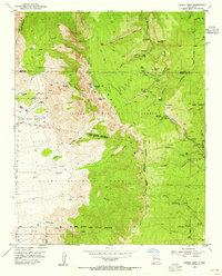
The Rio Grande valley north of Albuquerque is defined by a complex irrigation network in the mid-1950s, where the Main Canal and Corrales Main Canal supported agricultural life. Ancient land divisions persist through the large tracts of the Sandia Pueblo Grant and the Elena Gallegos Grant, showing a landscape still transitioning from rural estates to suburban expansion. The historic El Camino Real runs parallel to the Atchison Topeka and Santa Fe railroad, anchoring the settlements of Alameda and Corrales. Local education and community life are marked by the Sandia View Academy, Sandoval Sch, and the San Ysidro Ch. To the east, the terrain rises sharply into the Cibola National Forest, cut by deep drainages like Pino Canyon and Bear Canyon.
Find a feature on this map
35 named features on this map. Tap any name to fly to it.
Don’t see what you’re looking for? This feature index may not catch every label — zoom into the map to look around manually.
Map Details
Editions of this 1954 Alameda Map
This is the sole edition of this map. No revisions or reprints were ever made.
Other maps of this area

1888 · Bernalillo
USGS Topo · 1:125,000

1889 · Albuquerque
USGS Topo · 1:125,000

1892 · San Pedro
USGS Topo · 1:125,000

1893 · Albuquerque
USGS Topo · 1:125,000

1934 · Alameda
USGS Topo · 1:24,000

1934 · West Albuquerque
USGS Topo · 1:24,000

1934 · Griegos
USGS Topo · 1:24,000

1934 · East Albuquerque
USGS Topo · 1:24,000

1938 · Albuquerque
USGS Topo · 1:62,500
1954 · Sandia Crest
USGS Topo · 1:24,000
Featured Places
- Albuquerque, NM
- Corrales, NM
- Los Ranchos de Albuquerque, NM
- Prospectors Ridge, Albuquerque
- Academy Ridge East, Albuquerque