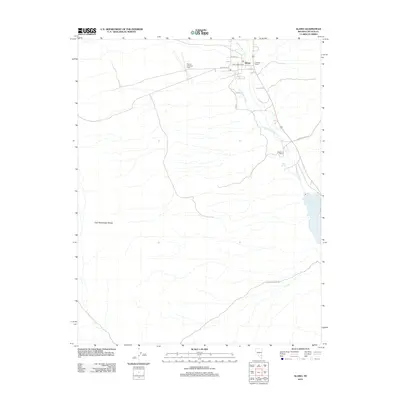
2012 Map of Alamo
USGS Topo · Published 2012About this map
Alamo serves as the focal point of this high-desert landscape in Lincoln County, where the ribbon of Pahranagat Creek provides a vital water source through the valley. The settlement is anchored by the Alamo Post Office and supported by local infrastructure like the Alamo Landing Field. Agricultural roots are evident in the outlying Piersons Ranch and Buckhorn Ranch, which sit between the water of Upper Pahranagat Lake and the rising slopes of the East Pahranagat Range.
Find a feature on this map
16 named features on this map. Tap any name to fly to it.
Don’t see what you’re looking for? This feature index may not catch every label — zoom into the map to look around manually.
Map Details
Editions of this 2012 Alamo Map
This is the sole edition of this map. No revisions or reprints were ever made.
Other maps of this area

1945 · Alamo
USGS Topo · 1:125,000

1954 · Caliente
USGS Topo · 1:250,000

1959 · Caliente
USGS Topo · 1:250,000

1969 · Alamo SE
USGS Topo · 1:24,000

1969 · Lower Pahranagat Lake
USGS Topo · 1:24,000

1969 · Alamo NE
USGS Topo · 1:24,000
1969 · Lower Pahranagat Lake NW
USGS Topo · 1:24,000

1969 · Alamo
USGS Topo · 1:24,000

1969 · Ash Springs
USGS Topo · 1:24,000
1980 · Alamo
USGS Topo · 1:24,000