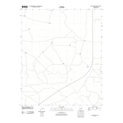
2010 Map of Alamo Ranch
USGS Topo · Published 2010About this map
Alamo Ranch sits at the heart of this high-plains landscape, where the survival of ranching operations depends heavily on a distributed network of groundwater access. The map reveals a land defined by its hydrology, with Yeso Creek winding through the southern half and a series of named water features dotting the terrain. These include isolated markers like Pennington Well and Buck Tank, alongside numerous family-named or location-specific windmills such as Miles Windmill, Star Windmill, and Rabbit Windmill. The road network, including County Rd-1-73 and County Rd-1-71, connects these remote outposts. This survey provides a precise look at the rural infrastructure of De Baca County in the early twenty-first century, documenting the critical role of windmills and tanks in maintaining the grazing lands of eastern New Mexico.
Find a feature on this map
18 named features on this map. Tap any name to fly to it.
Don’t see what you’re looking for? This feature index may not catch every label — zoom into the map to look around manually.
Map Details
Editions of this 2010 Alamo Ranch Map
This is the sole edition of this map. No revisions or reprints were ever made.
Other maps of this area

1954 · Fort Sumner
USGS Topo · 1:250,000

1958 · Fort Sumner
USGS Topo · 1:250,000

1965 · Fort Sumner West
USGS Topo · 1:24,000

1966 · West Camp
USGS Topo · 1:24,000

1966 · Alamo Ranch
USGS Topo · 1:24,000

1966 · Ricardo
USGS Topo · 1:24,000

1967 · Eighteenmile Hill
USGS Topo · 1:24,000

1967 · Conejo Creek West
USGS Topo · 1:24,000
1967 · Conejo Creek East
USGS Topo · 1:24,000

1968 · Fort Sumner East
USGS Topo · 1:24,000