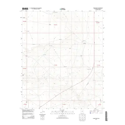
2013 Map of Alamo Ranch
USGS Topo · Published 2013About this map
Alamo Ranch sits within a landscape defined by critical water management and the rugged cattle-ranching traditions of De Baca County. This 2013 survey reveals a vast network of infrastructure dedicated to sustaining livestock in an arid environment, where named wells and windmills serve as the primary landmarks across the rangeland. Features such as Miles Windmill, Orchard Windmill, and Pennington Well are more than simple utility points; they mark the historic grazing territories and family operations that have shaped this region's economy for generations. The drainage patterns of Yeso Cr, Guana Draw, and Alamo Draw carve through the terrain, dictating the placement of roads like Renegade Rd and Tumbleweed Rd. The presence of NM-20 provides the main arterial connection through this sparsely populated territory, linking these remote ranching outposts to the wider world.
Find a feature on this map
31 named features on this map. Tap any name to fly to it.
Don’t see what you’re looking for? This feature index may not catch every label — zoom into the map to look around manually.
Map Details
Editions of this 2013 Alamo Ranch Map
This is the sole edition of this map. No revisions or reprints were ever made.
Other maps of this area

1954 · Fort Sumner
USGS Topo · 1:250,000

1958 · Fort Sumner
USGS Topo · 1:250,000

1965 · Fort Sumner West
USGS Topo · 1:24,000

1966 · West Camp
USGS Topo · 1:24,000

1966 · Alamo Ranch
USGS Topo · 1:24,000

1966 · Ricardo
USGS Topo · 1:24,000

1967 · Eighteenmile Hill
USGS Topo · 1:24,000

1967 · Conejo Creek West
USGS Topo · 1:24,000
1967 · Conejo Creek East
USGS Topo · 1:24,000

1968 · Fort Sumner East
USGS Topo · 1:24,000