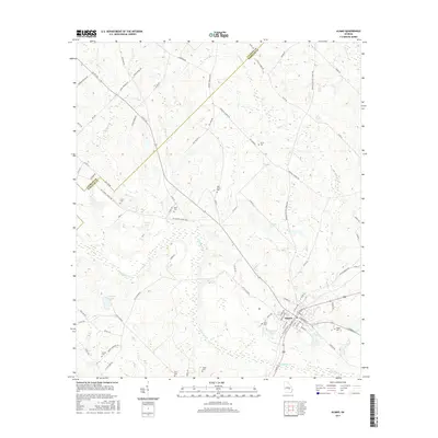
2017 Map of Alamo
USGS Topo · Published 2017About this map
Alamo serves as the focal point of this Wheeler County landscape, where the local road network radiates outward toward the Laurens County and Wheeler County line. The terrain is defined by a dense concentration of small family and community burial grounds, including Clark Cem, Grimes Cem, and Stuart Cem, which offer significant value for genealogical research in this part of Georgia. Hydrology plays a central role in the area's layout, with Alligator Creek and Little Creek carving through the countryside. Several notable water bodies, such as Morris Lake and O'Quinns Pond, are situated near the town center, reflecting the agrarian and water-dependent history of the region. The map also traces established routes like Mt Carmel Church Rd and Lowery Firehouse Rd, providing a clear view of contemporary rural infrastructure and land use.
Find a feature on this map
86 named features on this map. Tap any name to fly to it.
Don’t see what you’re looking for? This feature index may not catch every label — zoom into the map to look around manually.
Map Details
Editions of this 2017 Alamo Map
This is the sole edition of this map. No revisions or reprints were ever made.
Other maps of this area

1957 · Macon
USGS Topo · 1:250,000

1958 · Macon
USGS Topo · 1:250,000

1964 · Macon
USGS Topo · 1:250,000

1970 · Scotland
USGS Topo · 1:24,000

1970 · Glenwood
USGS Topo · 1:24,000

1970 · Alamo
USGS Topo · 1:24,000

1970 · Jordan
USGS Topo · 1:24,000

1971 · Lothair
USGS Topo · 1:24,000

1972 · Mc Rae NW
USGS Topo · 1:24,000
1972 · Mc Rae
USGS Topo · 1:24,000