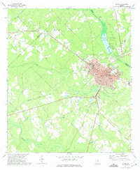
1972 Map of Mc Rae
USGS Topo · Published 1975About this map
McRae and Helena serve as the primary hubs of this region, established as twin cities where the Southern and Seaboard Coast Line railroads intersect. This 1972 survey illustrates the civic development of the era, noting essential community landmarks such as the County Hospital, City Hall, and Central Sch. Beyond the urban grid of streets like Telfair Ave and Liberty St, the landscape is defined by its waterways, including the winding Little Ocmulgee River and Sugar Creek.
Find a feature on this map
36 named features on this map. Tap any name to fly to it.
Don’t see what you’re looking for? This feature index may not catch every label — zoom into the map to look around manually.
Map Details
Editions of this 1972 Mc Rae Map
2 editions found
Other maps of this area

1953 · Waycross
USGS Topo · 1:250,000

1957 · Macon
USGS Topo · 1:250,000

1958 · Macon
USGS Topo · 1:250,000

1958 · Waycross
USGS Topo · 1:250,000

1964 · Macon
USGS Topo · 1:250,000

1970 · Scotland
USGS Topo · 1:24,000

1970 · Alamo
USGS Topo · 1:24,000

1971 · Jacksonville NE
USGS Topo · 1:24,000

1972 · Cooks Still
USGS Topo · 1:24,000

1972 · Mc Rae NW
USGS Topo · 1:24,000