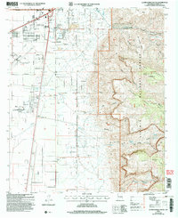
2004 Map of Alamogordo South
USGS Topo · Published 2006About this map
The expanding urban footprint of Alamogordo anchors the northwestern quadrant of this survey, where residential grids and industrial infrastructure meet the stark transition into the Lincoln National Forest. This 2004 revision reveals the city's growth in the early 21st century, showing the developed parcels and infrastructure reaching toward the high desert canyons. The map documents the relationship between the built environment of Otero County and the dramatic topography of the Sacramento Mountains to the east, illustrating how the regional transportation network and city planning have adapted to the alluvial fans and drainage patterns that define the local geography.
Find a feature on this map
1 named feature on this map. Tap any name to fly to it.
Don’t see what you’re looking for? This feature index may not catch every label — zoom into the map to look around manually.
Map Details
Editions of this 2004 Alamogordo South Map
This is the sole edition of this map. No revisions or reprints were ever made.
Other maps of this area

1916 · Point Of Sands
USGS Topo · 1:125,000

1948 · Tres Hermanos
USGS Topo · 1:62,500

1948 · Holloman
USGS Topo · 1:62,500

1950 · Escondido Canyon
USGS Topo · 1:62,500

1950 · Alamogordo
USGS Topo · 1:62,500

1954 · Carlsbad
USGS Topo · 1:250,000

1955 · Las Cruces
USGS Topo · 1:250,000

1958 · Las Cruces
USGS Topo · 1:250,000

1958 · Carlsbad
USGS Topo · 1:250,000

1976 · Mule Peak
USGS Topo · 1:24,000