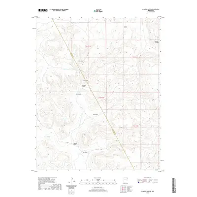
2020 Map of Alamosa Canyon
USGS Topo · Published 2020About this map
Alamosa Canyon and a series of rugged draws define this landscape on the border of San Miguel and Harding Counties. The area is characterized by high mesa terrain dissected by deep drainage systems like Salitre Canyon, Willie Canyon, and Dog Canyon. These natural corridors have long shaped movement through this part of New Mexico, evidenced by the diagonal survey boundary between Harding Co and San Miguel Co that cuts across the land. Water management is central to the history of this arid country, with a network of livestock tanks including Rincon Tank, Pothole Tank, and Seco Tank strategically placed near the canyon floors. At the eastern edge, Rincon Colorado marks a significant terrain feature near the headwaters of Wymm Cr, while ranch roads like Nana's Ln provide access to the remote interior sections.
Find a feature on this map
25 named features on this map. Tap any name to fly to it.
Don’t see what you’re looking for? This feature index may not catch every label — zoom into the map to look around manually.
Map Details
Editions of this 2020 Alamosa Canyon Map
This is the sole edition of this map. No revisions or reprints were ever made.
Other maps of this area

1930 · Tucumcari
USGS Topo · 1:125,000

1954 · Tucumcari
USGS Topo · 1:250,000

1958 · Tucumcari
USGS Topo · 1:250,000

1968 · Hampton Ranch
USGS Topo · 1:24,000

1968 · Carpenter Mesa NW
USGS Topo · 1:24,000
1968 · Medina Mesa
USGS Topo · 1:24,000

1969 · Gallegos
USGS Topo · 1:24,000

1969 · Salitre Canyon
USGS Topo · 1:24,000
1969 · Alamosa Canyon
USGS Topo · 1:24,000
1969 · Campana
USGS Topo · 1:24,000