
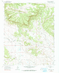
1964 Map of Alamosa Creek
USGS Topo · Published 1966About this map
Las Mesas Del Conjelon dominates the northern horizon of this mid-century survey, forming a massive elevated plateau that dictates the drainage of the surrounding Mora County landscape. Below these heights, the land breaks into a series of deeply incised canyons, including Cañon Alamito and Cañon Bonito, which channel seasonal water toward the lower plains. The era's ranching footprint is visible through isolated homesteads like Thompson Ranch and Daniels Ranch, positioned near reliable water sources such as Alamosa Creek.
Find a feature on this map
23 named features on this map. Tap any name to fly to it.
Don’t see what you’re looking for? This feature index may not catch every label — zoom into the map to look around manually.
Map Details
Editions of this 1964 Alamosa Creek Map
2 editions found
Other maps of this area

1892 · Watrous
USGS Topo · 1:125,000

1894 · Watrous
USGS Topo · 1:125,000

1954 · Santa Fe
USGS Topo · 1:250,000

1954 · Raton
USGS Topo · 1:250,000

1958 · Raton
USGS Topo · 1:250,000

1958 · Santa Fe
USGS Topo · 1:250,000

1964 · Wagon Mound
USGS Topo · 1:24,000

1964 · Alto De Hormiga
USGS Topo · 1:24,000

1964 · Frutosa Lake
USGS Topo · 1:24,000

1964 · Mogote Hills
USGS Topo · 1:24,000