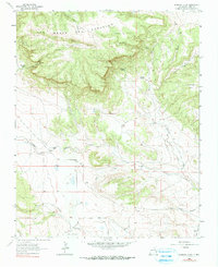
1964 Map of Alamosa Creek
USGS Topo · Published 1990About this map
Las Mesas Del Conjelon dominates the northern terrain of this Mora County landscape, where the plateau drops into a series of deep canyons and water-carved draws. The map captures a mid-century ranching environment, centered on remote outposts like Thompson Ranch and Daniels Ranch. These properties are tied to a complex hydrology of natural springs and intermittent flows, including Bootlegger Spring, El Rincon Springs, and Mayes Spring, which provided essential water for livestock in this high-elevation grazing country.
Find a feature on this map
25 named features on this map. Tap any name to fly to it.
Don’t see what you’re looking for? This feature index may not catch every label — zoom into the map to look around manually.
Map Details
Editions of this 1964 Alamosa Creek Map
2 editions found

Other maps of this area

1892 · Watrous
USGS Topo · 1:125,000

1894 · Watrous
USGS Topo · 1:125,000

1954 · Santa Fe
USGS Topo · 1:250,000

1954 · Raton
USGS Topo · 1:250,000

1958 · Raton
USGS Topo · 1:250,000

1958 · Santa Fe
USGS Topo · 1:250,000

1964 · Wagon Mound
USGS Topo · 1:24,000

1964 · Alto De Hormiga
USGS Topo · 1:24,000

1964 · Frutosa Lake
USGS Topo · 1:24,000

1964 · Mogote Hills
USGS Topo · 1:24,000