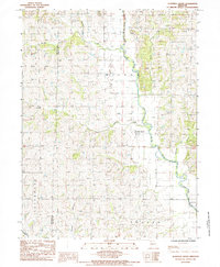
1985 Map of Alanthus Grove
USGS Topo · Published 1985About this map
The Grand River meanders through the heart of this Gentry County landscape, defining the rural character of northwest Missouri in the mid-1980s. The small settlements of Alanthus Grove and Enyart serve as the primary local hubs, situated among a complex network of waterways including Zounds Creek, Indian Creek, and Grantham Creek. This period of the county's history is marked by a traditional agrarian land pattern, with numerous small Cem sites scattered across the townships of Jackson, Wilson, Jefferson, and Cooper. The map also captures the political geography of the era, illustrating the boundary between Nodaway County and Gentry County. The intricate drainage system, featuring Munkres Branch and Chapman Branch, illustrates the natural irrigation and topography that shaped local farmsteads and settlement placement.
Find a feature on this map
16 named features on this map. Tap any name to fly to it.
Don’t see what you’re looking for? This feature index may not catch every label — zoom into the map to look around manually.
Map Details
Editions of this 1985 Alanthus Grove Map
This is the sole edition of this map. No revisions or reprints were ever made.
Other maps of this area

1925 · Stanberry
USGS Topo · 1:62,500

1925 · Darlington
USGS Topo · 1:62,500

1939 · Stanberry
USGS Topo · 1:62,500

1940 · Parnell
USGS Topo · 1:62,500

1942 · Grant City
USGS Topo · 1:62,500

1943 · Parnell
USGS Topo · 1:62,500

1943 · Grant City
USGS Topo · 1:62,500

1943 · Stanberry
USGS Topo · 1:62,500

1950 · Darlington
USGS Topo · 1:62,500

1955 · Nebraska City
USGS Topo · 1:250,000