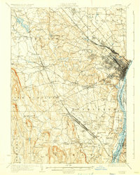
1927 Map of Albany
USGS Topo · Published 1930About this map
The Hudson River shoreline and its industrial rail corridors dominate this late 1920s landscape, where the Albany urban grid meets the rural townships of Colonie, Guilderland, and Bethlehem. The topography transitions from the alluvial plains of the river, dotted with islands like Papsanee Island and Schermerhorn Island, to the dramatic rising elevations of the Helderberg Mountains in the west. A heavy concentration of rail infrastructure is evident, including the massive Selkirk Yards and the Castleton Cutoff, which facilitated freight movement around the capital city.
Find a feature on this map
109 named features on this map. Tap any name to fly to it.
Don’t see what you’re looking for? This feature index may not catch every label — zoom into the map to look around manually.
Map Details
Editions of this 1927 Albany Map
5 editions found

Other maps of this area

1893 · Cohoes
USGS Topo · 1:62,500

1893 · Troy
USGS Topo · 1:62,500

1893 · Schenectady
USGS Topo · 1:62,500

1893 · Coxsackie
USGS Topo · 1:62,500

1893 · Durham
USGS Topo · 1:62,500

1893 · Albany
USGS Topo · 1:62,500

1894 · Coxsackie
USGS Topo · 1:62,500

1894 · Durham
USGS Topo · 1:62,500

1895 · Troy
USGS Topo · 1:62,500

1895 · Cohoes
USGS Topo · 1:62,500