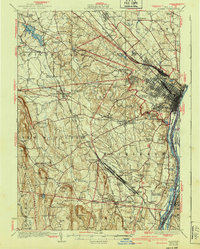
1927 Map of Albany
USGS Topo · Published 1940About this map
The Albany region and its vital rail corridors are documented here just before the mid-century, showing a landscape defined by industrial infrastructure and expanding commuter settlements. The massive Selkirk Yards anchor the rail network in Bethlehem, while the New York Central and Hudson River RR and Delaware and Hudson RR converge on the city. To the west, the Helderberg Mountains rise abruptly, featuring the protected grounds of John Boyd Thacher Park.
Find a feature on this map
113 named features on this map. Tap any name to fly to it.
Don’t see what you’re looking for? This feature index may not catch every label — zoom into the map to look around manually.
Map Details
Editions of this 1927 Albany Map
5 editions found

Other maps of this area

1893 · Cohoes
USGS Topo · 1:62,500

1893 · Troy
USGS Topo · 1:62,500

1893 · Schenectady
USGS Topo · 1:62,500

1893 · Coxsackie
USGS Topo · 1:62,500

1893 · Durham
USGS Topo · 1:62,500

1893 · Albany
USGS Topo · 1:62,500

1894 · Coxsackie
USGS Topo · 1:62,500

1894 · Durham
USGS Topo · 1:62,500

1895 · Troy
USGS Topo · 1:62,500

1895 · Cohoes
USGS Topo · 1:62,500