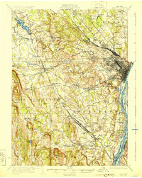
1927 Map of Albany
USGS Topo · Published 1930About this map
The Hudson River serves as the eastern anchor for this region, framing a landscape defined by its transition from the urban density of Albany to the dramatic limestone escarpments of the Helderberg Mountains in the west. This era reveals a complex web of transportation infrastructure, where the New York Central RR and the Delaware and Hudson RR converge near the massive Belkirk Yards. These rail corridors fostered the growth of commuter hamlets like Slingerlands, Delmar, and Elsmere, which are shown here in their early development along the rail lines.
Find a feature on this map
120 named features on this map. Tap any name to fly to it.
Don’t see what you’re looking for? This feature index may not catch every label — zoom into the map to look around manually.
Map Details
Editions of this 1927 Albany Map
5 editions found

Other maps of this area

1893 · Cohoes
USGS Topo · 1:62,500

1893 · Troy
USGS Topo · 1:62,500

1893 · Schenectady
USGS Topo · 1:62,500

1893 · Coxsackie
USGS Topo · 1:62,500

1893 · Durham
USGS Topo · 1:62,500

1893 · Albany
USGS Topo · 1:62,500

1894 · Coxsackie
USGS Topo · 1:62,500

1894 · Durham
USGS Topo · 1:62,500

1895 · Troy
USGS Topo · 1:62,500

1895 · Cohoes
USGS Topo · 1:62,500