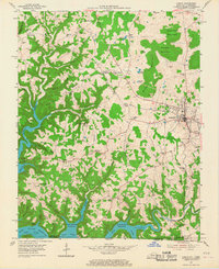
1954 Map of Albany
USGS Topo · Published 1967About this map
The county seat of Albany dominates this mid-century landscape, positioned at a significant crossroads before the terrain breaks into the deep ridges and valleys of the Cumberland plateau. To the south and west, the flooding of the Wolf River has created the expansive Dale Hollow Reservoir, a major geographic shift that redefined the local economy and geography in the 1940s and 50s. The map illustrates the rise of water-based recreation and commerce with the appearance of Wisdom Dock and Wolf River Dock along the new shoreline.
Find a feature on this map
64 named features on this map. Tap any name to fly to it.
Don’t see what you’re looking for? This feature index may not catch every label — zoom into the map to look around manually.
Map Details
Editions of this 1954 Albany Map
2 editions found
Other maps of this area

1924 · Lillydale
USGS Topo · 1:62,500

1926 · Lillydale
USGS Topo · 1:62,500

1929 · Lillydale
USGS Topo · 1:62,500

1929 · Byrdstown
USGS Topo · 1:62,500

1953 · Burkesville
USGS Topo · 1:24,000

1953 · Wolf Creek Dam
USGS Topo · 1:24,000

1954 · Frogue
USGS Topo · 1:24,000

1954 · Cumberland City
USGS Topo · 1:24,000

1954 · Albany
USGS Topo · 1:24,000

1954 · Savage
USGS Topo · 1:24,000