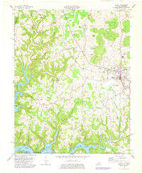
1978 Map of Albany
USGS Topo · Published 1978About this map
The town of Albany serves as the focal point of this Clinton County survey, situated amidst the complex terrain of Pickens Ridge and Huddleston Mountain. The landscape is defined by the encroaching waters of Dale Hollow Lake and Wolf River Lake along the southern border, where Wisdom Dock and Wolf River Dock provide access to the transformed river valleys. Evidence of the local extraction economy is scattered across the uplands, noted by numerous Oil Wells and established Oil and Gas Fields near Tuggle Creek. Small rural communities and family landmarks are densely packed into the hollows and along the ridges, including Palestine Ch and the settlement of Shipley. Further south, the map documents the proximity to the Tennessee border near Huntersville, capturing the transition from agricultural uplands to the engineered waterways of the Cumberland basin.
Find a feature on this map
64 named features on this map. Tap any name to fly to it.
Don’t see what you’re looking for? This feature index may not catch every label — zoom into the map to look around manually.
Map Details
Editions of this 1978 Albany Map
2 editions found
Other maps of this area

1924 · Lillydale
USGS Topo · 1:62,500

1926 · Lillydale
USGS Topo · 1:62,500

1929 · Lillydale
USGS Topo · 1:62,500

1929 · Byrdstown
USGS Topo · 1:62,500

1953 · Burkesville
USGS Topo · 1:24,000

1953 · Wolf Creek Dam
USGS Topo · 1:24,000

1954 · Frogue
USGS Topo · 1:24,000

1954 · Cumberland City
USGS Topo · 1:24,000

1954 · Albany
USGS Topo · 1:24,000

1954 · Savage
USGS Topo · 1:24,000