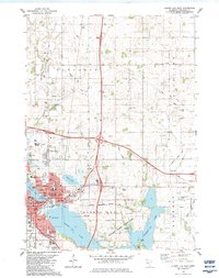
1982 Map of Albert Lea East
USGS Topo · Published 1983About this map
Albert Lea serves as a major hub for southern Minnesota in the early 1980s, defined by its complex relationship with the waters of Albert Lea Lake and Fountain Lake. This survey illustrates the town’s significant expansion as a regional center, showcasing essential infrastructure like the Albert Lea Municipal Airport, Naeve Hospital, and the Albert Lea Vo-Tech Institute. The town's grid is surrounded by a patchwork of conservation and recreation areas, including Helmer Myre State Park and Bancroft Bay Park, which buffer the residential core from the surrounding agricultural and industrial landscapes.
Find a feature on this map
65 named features on this map. Tap any name to fly to it.
Don’t see what you’re looking for? This feature index may not catch every label — zoom into the map to look around manually.
Map Details
Editions of this 1982 Albert Lea East Map
This is the sole edition of this map. No revisions or reprints were ever made.
Other maps of this area

1954 · Albert Lea
USGS Topo · 1:62,500

1954 · Hayward
USGS Topo · 1:62,500

1954 · Mason City
USGS Topo · 1:250,000

1957 · Mason City
USGS Topo · 1:250,000

1958 · Mason City
USGS Topo · 1:250,000

1967 · Hollandale
USGS Topo · 1:24,000

1967 · Hartland
USGS Topo · 1:24,000

1967 · Ellendale
USGS Topo · 1:24,000

1982 · Hayward
USGS Topo · 1:24,000

1982 · Albert Lea West
USGS Topo · 1:24,000