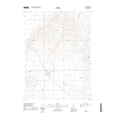
2020 Map of Albion
USGS Topo · Published 2020About this map
The town of Albion serves as the central hub of this Cassia County landscape, situated where the Albion Mountains meet the valley floor. The map documents the intricate network of water management and natural drainage essential to this high-desert region, featuring the J Canal and numerous seasonal flows like Marsh Cr, Howell Cr, and Land Cr. Genealogists and local historians will find the Pleasant Hill Cem clearly marked just north of the town center, while the grid of rural roads such as Chatburn Rd and Walton Ln provides a precise look at modern land division. The surrounding topography is defined by significant elevation changes, from the East Hills to the deep recesses of White Pine Canyon and Harroun Canyon. This detailed view of the area reveals how contemporary settlement patterns continue to follow the natural contours and water sources like Bridger Spring and Water Canyon Spring.
Find a feature on this map
43 named features on this map. Tap any name to fly to it.
Don’t see what you’re looking for? This feature index may not catch every label — zoom into the map to look around manually.
Map Details
Editions of this 2020 Albion Map
This is the sole edition of this map. No revisions or reprints were ever made.
Other maps of this area

1954 · Pocatello
USGS Topo · 1:250,000

1958 · Pocatello
USGS Topo · 1:250,000

1959 · Lake Walcott
USGS Topo · 1:62,500

1964 · Rupert SE
USGS Topo · 1:24,000

1964 · View
USGS Topo · 1:24,000

1964 · Rupert SW
USGS Topo · 1:24,000

1968 · Idahome
USGS Topo · 1:24,000

1968 · Mount Harrison
USGS Topo · 1:24,000

1968 · Nibbs Creek
USGS Topo · 1:24,000

1968 · Albion
USGS Topo · 1:24,000