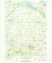
1956 Map of Albion
USGS Topo · Published 1958About this map
Albion serves as the central hub of this mid-century Indiana survey, situated at the junction of the Baltimore and Ohio Railroad and a network of county roads. The landscape is defined by the headwaters of the Elkhart River and its various branches, including the South Branch Elkhart River, which snake through a mix of fertile farmland and scattered marshy depressions like The Spread. Small settlements like Wawaka, Brimfield, and Rome City are connected by the New York Central and St. Louis Railroad, illustrating the vital role of rail transport in Noble County's post-war economy. Local institutions such as the County Home, Albion-Jefferson Township Sch, and the County 4H Park provide a clear view of the civic and social infrastructure of the time, while family history is grounded in sites like Rose Hill Cemetery and Orange Cem.
Find a feature on this map
41 named features on this map. Tap any name to fly to it.
Don’t see what you’re looking for? This feature index may not catch every label — zoom into the map to look around manually.
Map Details
Editions of this 1956 Albion Map
2 editions found
Other maps of this area

1947 · Wolcottville
USGS Topo · 1:24,000

1947 · Oliver Lake
USGS Topo · 1:24,000

1951 · Ormas
USGS Topo · 1:24,000

1951 · Merriam
USGS Topo · 1:24,000

1953 · Fort Wayne
USGS Topo · 1:250,000

1955 · Ege
USGS Topo · 1:24,000

1955 · Kendallville
USGS Topo · 1:24,000

1956 · Fort Wayne
USGS Topo · 1:250,000

1956 · Ligonier
USGS Topo · 1:24,000

1956 · Albion
USGS Topo · 1:24,000