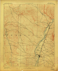
1893 Map of Albuquerque
USGS Topo · Published 1914About this map
Albuquerque serves as the focal point of this late 19th-century reconnaissance, situated along the eastern bank of the Rio Grande during a period of rapid Western expansion. The map illustrates the early alignment of the Atchison Topeka and Santa Fe Railroad, which follows the river valley and connects the main settlement to northern outposts like Bernalillo and Sandia. The landscape is defined by the contrast between the fertile valley floor, dotted with older Spanish-named settlements such as Alameda, Corales, and Ranchos de Albuquerque, and the high, arid desert plateaus to the west. Farther afield, the Rio Puerco and Jemez Creek provide essential water sources for more isolated locales like San Ygnacio and Santa Ana. This document provides a rare perspective of the territorial era before modern urbanization reshaped the valley's original layout and irrigation patterns.
Find a feature on this map
15 named features on this map. Tap any name to fly to it.
Don’t see what you’re looking for? This feature index may not catch every label — zoom into the map to look around manually.
Map Details
Editions of this 1893 Albuquerque Map
5 editions found
Other maps of this area

1883 · Mt. Taylor
USGS Topo · 1:250,000

1886 · Mt. Taylor
USGS Topo · 1:250,000

1888 · Bernalillo
USGS Topo · 1:125,000

1889 · Albuquerque
USGS Topo · 1:125,000

1890 · Jemes
USGS Topo · 1:125,000

1892 · San Pedro
USGS Topo · 1:125,000

1892 · Jemes
USGS Topo · 1:125,000

1892 · Santa Clara
USGS Topo · 1:125,000

1892 · Mt. Taylor
USGS Topo · 1:250,000

1893 · Albuquerque
USGS Topo · 1:125,000