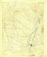
1893 Map of Albuquerque
USGS Topo · Published 1932About this map
The Rio Grande valley serves as the central artery for New Mexico life in this late-19th-century survey, anchoring a string of historic settlements from Bernalillo and Alameda south to the growing grid of Albuquerque. West of the river, the landscape transitions into the sparse drainage basin of the Rio Puerco, where small outposts like San Ygnacio and San Francisco sit along the western edge of the quadrangle. The arrival of the Atchison Topeka and Santa Fe Railroad is clearly evident, running parallel to the river and connecting the older agricultural plazas like Atrisco and Ranchos de Albuquerque to the modernizing rail corridor.
Find a feature on this map
16 named features on this map. Tap any name to fly to it.
Don’t see what you’re looking for? This feature index may not catch every label — zoom into the map to look around manually.
Map Details
Editions of this 1893 Albuquerque Map
5 editions found
Other maps of this area

1883 · Mt. Taylor
USGS Topo · 1:250,000

1886 · Mt. Taylor
USGS Topo · 1:250,000

1888 · Bernalillo
USGS Topo · 1:125,000

1889 · Albuquerque
USGS Topo · 1:125,000

1890 · Jemes
USGS Topo · 1:125,000

1892 · San Pedro
USGS Topo · 1:125,000

1892 · Jemes
USGS Topo · 1:125,000

1892 · Santa Clara
USGS Topo · 1:125,000

1892 · Mt. Taylor
USGS Topo · 1:250,000

1893 · Albuquerque
USGS Topo · 1:125,000