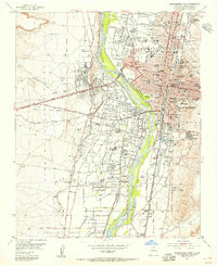
1954 Map of Albuquerque West
USGS Topo · Published 1955About this map
The Rio Grande valley dictates the mid-century development of this region, where traditional agricultural settlements like Atrisco and Armijo stand in contrast to the rapidly expanding urban core of Albuquerque. Irrigation and drainage systems, including the Albuquerque Riverside Drain and Arenal Canal, define the valley floor's fertile character between the river and the rising West Mesa. The map captures a significant period of institutional growth, marking the US Indian School, St. Vincents Academy, and the New Mexico Girls Welfare Home. Transportation and industry follow the Atchison Topeka and Santa Fe railroad line, while established neighborhood centers such as Old Town and Martinez Town maintain their historic footprints amidst the burgeoning 1950s suburbs.
Find a feature on this map
92 named features on this map. Tap any name to fly to it.
Don’t see what you’re looking for? This feature index may not catch every label — zoom into the map to look around manually.
Map Details
Editions of this 1954 Albuquerque West Map
This is the sole edition of this map. No revisions or reprints were ever made.
Other maps of this area

1888 · Bernalillo
USGS Topo · 1:125,000

1889 · Albuquerque
USGS Topo · 1:125,000

1893 · Albuquerque
USGS Topo · 1:125,000

1934 · Alameda
USGS Topo · 1:24,000

1934 · West Albuquerque
USGS Topo · 1:24,000

1934 · Griegos
USGS Topo · 1:24,000

1934 · East Albuquerque
USGS Topo · 1:24,000

1938 · Albuquerque
USGS Topo · 1:62,500

1952 · Wind Mesa
USGS Topo · 1:24,000

1952 · Hubbell Spring
USGS Topo · 1:24,000