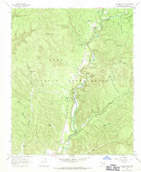
1967 Map of Alchesay Flat
USGS Topo · Published 1971About this map
Alchesay Flat and the surrounding canyonlands of the Fort Apache Indian Reservation dominate this mid-century landscape in Navajo County. The mapping reveals a distinct pattern of human presence centered along the North Fork White River, where the Alchesay National Fish Hatchery and numerous campgrounds utilize the river's resources. Of significant historical interest is the Chief Alchesay Baha Grave located near petroglyphs and the Baha Ranch, marking a specific cultural geography on the White Mountain Apache lands. The terrain is defined by deep incisions like Post Office Canyon and Bear Canyon, while landmarks such as Little Round Top Mtn and Gold Butte rise above the flats. Numerous water sources, including Columbine Spring and Yellow Jacket Spring, are dispersed throughout the high country, indicating the essential role of springs in this environment.
Find a feature on this map
52 named features on this map. Tap any name to fly to it.
Don’t see what you’re looking for? This feature index may not catch every label — zoom into the map to look around manually.
Map Details
Editions of this 1967 Alchesay Flat Map
This is the sole edition of this map. No revisions or reprints were ever made.
Other maps of this area

1886 · St Johns
USGS Topo · 1:250,000

1886 · Holbrook
USGS Topo · 1:250,000

1892 · St Johns
USGS Topo · 1:250,000

1893 · Holbrook
USGS Topo · 1:250,000

1954 · Holbrook
USGS Topo · 1:250,000

1954 · Clifton
USGS Topo · 1:250,000

1954 · Saint Johns
USGS Topo · 1:250,000

1954 · Mesa
USGS Topo · 1:250,000

1957 · Mesa
USGS Topo · 1:250,000

1957 · Holbrook
USGS Topo · 1:250,000