
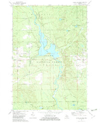
1972 Map of Alcona Dam Pond
USGS Topo · Published 1975About this map
The Au Sable River carves through the landscape of the Huron National Forest, dominated by the extensive Alcona Dam Pond created by the Alcona Dam. This 1970s survey illustrates a region shaped by hydro-electric infrastructure and forestry, with a powerplant and substation situated at the dam site to harness the river's flow. The settlement of Curtisville serves as the local hub, featuring the Curtisville Civic Center and the Curtisville Cem nearby.
Find a feature on this map
42 named features on this map. Tap any name to fly to it.
Don’t see what you’re looking for? This feature index may not catch every label — zoom into the map to look around manually.
Map Details
Editions of this 1972 Alcona Dam Pond Map
2 editions found
Other maps of this area

1954 · Tawas City
USGS Topo · 1:250,000

1958 · Tawas City
USGS Topo · 1:250,000

1959 · Tawas City
USGS Topo · 1:62,500

1959 · Glennie
USGS Topo · 1:62,500

1968 · Hale
USGS Topo · 1:24,000

1968 · South Branch
USGS Topo · 1:24,000

1972 · McKinley
USGS Topo · 1:24,000

1972 · Curran
USGS Topo · 1:24,000

1972 · Goodar
USGS Topo · 1:24,000

1983 · Hubbard Lake
USGS Topo · 1:100,000
Featured Places
- Curtis Township, MI
- Mitchell Township, MI
- Plainfield Township, MI
- Oscoda Township, MI
- Millen Township, MI