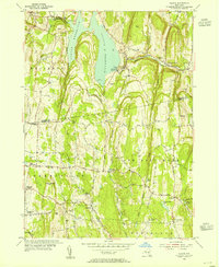
1953 Map of Alcove
USGS Topo · Published 1955About this map
Alcove Reservoir dominates the landscape of southern Albany and northern Greene counties, its waters contained by a prominent spillway near the village of Alcove. The terrain is defined by a dense network of country roads like Whitbeck Road and Honey Hollow Road, which connect longstanding rural settlements and agricultural hamlets. Genealogists will find a wealth of local landmarks, including numerous family and community burial grounds such as Staco Cem, Powell Cem, and the Indian Fields Cem. Educational history is preserved through remnants like School No 7 and Sch No 10, while the presence of a Gaging Sta and a Quarry near Mossy Hill reflects the mid-century intersection of natural resource management and local industry. The map captures the quiet transition of small communities like Dormansville, Grapeville, and Coeymans Hollow before the era of major modern development.
Find a feature on this map
54 named features on this map. Tap any name to fly to it.
Don’t see what you’re looking for? This feature index may not catch every label — zoom into the map to look around manually.
Map Details
Editions of this 1953 Alcove Map
3 editions found
Other maps of this area

1893 · Coxsackie
USGS Topo · 1:62,500

1893 · Durham
USGS Topo · 1:62,500

1893 · Albany
USGS Topo · 1:62,500

1894 · Coxsackie
USGS Topo · 1:62,500

1894 · Durham
USGS Topo · 1:62,500

1895 · Albany
USGS Topo · 1:62,500

1898 · Albany
USGS Topo · 1:62,500

1900 · Berne
USGS Topo · 1:62,500

1903 · Berne
USGS Topo · 1:62,500

1927 · Albany
USGS Topo · 1:62,500