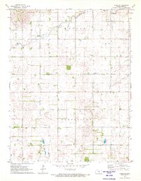
1971 Map of Alden SE
USGS Topo · Published 1972About this map
Huntsville serves as the primary node of this rural landscape in central Kansas, positioned along the border of Huntsville and Hayes townships. The area is characterized by a sparse network of section-line roads and the meandering courses of Peace Creek and Salt Creek. Local history is anchored by the Huntsville Cem and Pleasant View Cem, along with a centralized Townhall and the Sterling Ch. The landscape reveals an active extraction economy, with numerous Oil Wells scattered across the grid, particularly concentrated in the southern half of the map. This 1971 survey shows the region's agricultural layout just before modern consolidation, preserving the locations of individual rural homesteads and local civic landmarks.
Find a feature on this map
14 named features on this map. Tap any name to fly to it.
Don’t see what you’re looking for? This feature index may not catch every label — zoom into the map to look around manually.
Map Details
Editions of this 1971 Alden SE Map
2 editions found
Other maps of this area

1892 · Kingman
USGS Topo · 1:125,000

1894 · Kingman
USGS Topo · 1:125,000

1894 · Lyons
USGS Topo · 1:125,000

1955 · Great Bend
USGS Topo · 1:250,000

1955 · Pratt
USGS Topo · 1:250,000

1957 · Great Bend
USGS Topo · 1:250,000

1958 · Great Bend
USGS Topo · 1:250,000

1959 · Pratt
USGS Topo · 1:250,000

1966 · Sterling SW
USGS Topo · 1:24,000

1967 · Alden
USGS Topo · 1:24,000