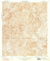
1941 Map of Alder Creek
USGS Topo · Published 1960About this map
Monte Cristo Mine and the Falcon Mine speak to the early prospecting history of the San Gabriel Mountains as captured in this mid-century survey. Within the high peaks and steep drainage of the Angeles National Forest, the Loomis Ranch remains a notable isolated settlement amidst a landscape defined by seasonal springs and mountain summits like Pacifico Mtn and Granite Mtn. The map documents a period of early infrastructure development in the backcountry, showing the Angeles Forest Highway winding through the terrain alongside clearings like Chilao Flats. This 1941 edition, revised with 1948 culture, also records the placement of the Chilao Guard Station and the State Highway Maintenance Sta, indicating the growing administrative and fire-prevention presence of the U.S. Forest Service and Los Angeles County. Networked firebreaks are etched across the ridges, and numerous springs such as Fountainhead Spring and Sheepcamp Spring are identified as critical water sources in the high country.
Find a feature on this map
32 named features on this map. Tap any name to fly to it.
Don’t see what you’re looking for? This feature index may not catch every label — zoom into the map to look around manually.
Map Details
Editions of this 1941 Alder Creek Map
3 editions found
Other maps of this area

1900 · Tujunga
USGS Topo · 1:62,500

1901 · Southern California Sheet No. 1
USGS Topo · 1:250,000

1903 · Rock Creek
USGS Topo · 1:62,500

1904 · Southern California Sheet No. 1
USGS Topo · 1:250,000
1934 · Cima Mesa
USGS Topo · 1:24,000
1934 · Mt. Lowe
USGS Topo · 1:24,000
1934 · Mt. Wilson
USGS Topo · 1:24,000
1934 · Acton
USGS Topo · 1:24,000

1934 · Chileno Canyon
USGS Topo · 1:24,000

1935 · Mt. Emma
USGS Topo · 1:24,000