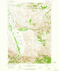
1963 Map of Alder
USGS Topo · Published 1965About this map
The Ruby Valley irrigation network defines this 1963 survey of Madison County, showing an intricate system of water management including the Vigilante Canal, West Bench Canal, and numerous family-named channels like the Phillips Ditch and Putnam Ditch. This hydraulic landscape supports the settlements of Laurin and the area near the Alder Rest Home, situated where Alder Gulch meets the valley floor. The Northern Pacific railroad line runs parallel to the Ruby River, serving a region marked by both agricultural persistence and mineral interests, such as the St Lawrence Mine in the eastern uplands. Genealogists will find significant value in the documentation of local burial sites, including the Laurin Cem, Ruby Cem, and Taylor Cem, which anchor the historical record of these Montana communities.
Find a feature on this map
37 named features on this map. Tap any name to fly to it.
Don’t see what you’re looking for? This feature index may not catch every label — zoom into the map to look around manually.
Map Details
Editions of this 1963 Alder Map
3 editions found
Other maps of this area

1888 · Three Forks
USGS Topo · 1:250,000

1893 · Dillon
USGS Topo · 1:250,000

1894 · Three Forks
USGS Topo · 1:250,000

1895 · Three Forks
USGS Topo · 1:250,000

1947 · Bozeman
USGS Topo · 1:250,000

1948 · Bozeman
USGS Topo · 1:250,000

1949 · Varney
USGS Topo · 1:62,500

1950 · Virginia City
USGS Topo · 1:62,500

1955 · Bozeman
USGS Topo · 1:250,000

1955 · Dillon
USGS Topo · 1:250,000