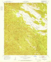
1949 Map of Alder Peak
USGS Topo · Published 1953About this map
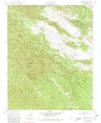
Hunter Liggett Military Reservation dominates the landscape of this 1949 survey, where military utility and conservation boundaries intersect along the Santa Lucia Range. The terrain is defined by the canyon systems of the Nacimiento River and Stony Creek, with the rugged topography culminating at Alder Peak. This era shows the land in transition, with established agricultural outposts like the San Miguelito Ranch situated near an Observation Post and the San Miguelito Loop Road. The map provides a detailed view of the Los Padres National Forest boundary, charting remote water sources such as Sycamore Spr and Basket Spr that were vital for both forestry and early ranching. A notable Telephone Line cuts across the northern canyons, marking the sparse infrastructure of this Monterey County backcountry.
Find a feature on this map
23 named features on this map. Tap any name to fly to it.
Don’t see what you’re looking for? This feature index may not catch every label — zoom into the map to look around manually.
Map Details
Editions of this 1949 Alder Peak Map
7 editions found
Other maps of this area

1919 · King City
USGS Topo · 1:62,500

1919 · Junipero Serra
USGS Topo · 1:62,500

1919 · Bryson
USGS Topo · 1:62,500

1921 · Cape San Martin
USGS Topo · 1:62,500

1939 · King City
USGS Topo · 1:62,500

1941 · Cape San Martin
USGS Topo · 1:62,500

1941 · Junipero Serra
USGS Topo · 1:62,500

1941 · Bryson
USGS Topo · 1:62,500

1942 · Bryson
USGS Topo · 1:62,500

1942 · Cape San Martin
USGS Topo · 1:62,500