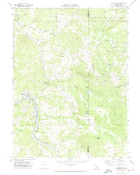
1969 Map of Alderpoint
USGS Topo · Published 1974About this map
Alderpoint serves as the central hub of this late-1960s survey, situated along a sharp bend in the Eel River. The settlement's infrastructure is dominated by the Northwestern Pacific railroad corridor and local services like the Alderpoint Forest Fire Sta. The surrounding landscape is defined by the complex drainage of Dobbyn Creek and its various forks, cutting through the southern reaches of the Six Rivers National Forest.
Find a feature on this map
42 named features on this map. Tap any name to fly to it.
Don’t see what you’re looking for? This feature index may not catch every label — zoom into the map to look around manually.
Map Details
Editions of this 1969 Alderpoint Map
2 editions found
Other maps of this area

1918 · Anada
USGS Topo · 1:62,500

1920 · Harris
USGS Topo · 1:62,500

1921 · Hoaglin
USGS Topo · 1:62,500

1922 · Island Mountain
USGS Topo · 1:62,500

1931 · Hoaglin
USGS Topo · 1:96,000

1935 · Hoaglin
USGS Topo · 1:125,000

1949 · Blocksburg
USGS Topo · 1:62,500

1949 · Alderpoint
USGS Topo · 1:62,500

1951 · Alderpoint
USGS Topo · 1:62,500

1951 · Blocksburg
USGS Topo · 1:62,500