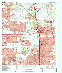
1995 Map of Aldine
USGS Topo · Published 1999About this map
The Bammel and Gas Field dominates the northern reaches of this Harris County landscape, signaling the intensive energy extraction that shaped the region's development. By the mid-1990s, the area reflects a complex transition from industrial activity to suburban density, centered around the unincorporated community of Aldine. Subdivisions such as Rushwood, Woodgate, and Fallbrook are etched into the terrain between the meandering courses of Greens Bayou and Halls Bayou.
Find a feature on this map
57 named features on this map. Tap any name to fly to it.
Don’t see what you’re looking for? This feature index may not catch every label — zoom into the map to look around manually.
Map Details
Editions of this 1995 Aldine Map
This is the sole edition of this map. No revisions or reprints were ever made.
Other maps of this area

1915 · Houston Heights
USGS Topo · 1:24,000

1915 · Hillendahl
USGS Topo · 1:24,000

1916 · Aldine
USGS Topo · 1:24,000

1916 · Settegast
USGS Topo · 1:24,000

1916 · Louetta
USGS Topo · 1:24,000

1916 · Satsuma
USGS Topo · 1:24,000

1916 · Humble
USGS Topo · 1:24,000

1916 · Spring
USGS Topo · 1:24,000

1918 · Hillendahl
USGS Topo · 1:31,680

1919 · Aldine
USGS Topo · 1:31,680