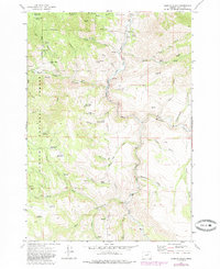
1972 Map of Aldrich Gulch
USGS Topo · Published 1985About this map
The South Fork John Day River cuts a deep path through the eastern reaches of the Ochoco National Forest in this 1970s landscape. The terrain is defined by a dense network of high ridges and deep gulches, such as Aldrich Gulch and Black Canyon, where water management for livestock and timber is evident through numerous small impoundments like Wigwam Reservoir and Ringsmeyer Reservoir. Settled history is marked by isolated homesteads and ranch sites, notably the Sundstrom Place (Site) and Black Canyon Ranch, situated along the few accessible benches above the river. The map details an era of heavy backcountry access, shown through named pack trails like the Payten Trail and Pullen Trail, which connect high points like Battle Creek Mountain and Youngs Butte to the valley floors.
Find a feature on this map
57 named features on this map. Tap any name to fly to it.
Don’t see what you’re looking for? This feature index may not catch every label — zoom into the map to look around manually.
Map Details
Editions of this 1972 Aldrich Gulch Map
2 editions found
Other maps of this area

1932 · Dayville
USGS Topo · 1:125,000

1936 · Dayville
USGS Topo · 1:125,000

1940 · Aldrich Mtn.
USGS Topo · 1:62,500

1943 · Aldrich Mtn.
USGS Topo · 1:62,500

1955 · Canyon City
USGS Topo · 1:250,000

1959 · Canyon City
USGS Topo · 1:250,000

1961 · Izee
USGS Topo · 1:62,500

1972 · Wolf Mountain
USGS Topo · 1:24,000

1972 · Day Basin
USGS Topo · 1:24,000
1972 · Aldrich Mountain North
USGS Topo · 1:24,000