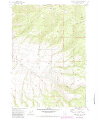
1972 Map of Aldrich Mountain South
USGS Topo · Published 1984About this map
Malheur National Forest dominates this section of Grant County, where the high elevation of Aldrich Mtn and Timber Mountain defines the drainage patterns of the eastern Oregon interior. The map documents a landscape of steep gulches and ridges, where water sources like Big Pine Springs and Roaring Spring were critical for local activity. Evidence of human presence is concentrated in small outposts and agricultural sites, notably the Murderers Creek Ranch and isolated structures like Weaver Cabin.
Find a feature on this map
41 named features on this map. Tap any name to fly to it.
Don’t see what you’re looking for? This feature index may not catch every label — zoom into the map to look around manually.
Map Details
Editions of this 1972 Aldrich Mountain South Map
2 editions found
Other maps of this area

1932 · Dayville
USGS Topo · 1:125,000

1936 · Dayville
USGS Topo · 1:125,000

1940 · Aldrich Mtn.
USGS Topo · 1:62,500

1943 · Aldrich Mtn.
USGS Topo · 1:62,500

1955 · Canyon City
USGS Topo · 1:250,000

1959 · Canyon City
USGS Topo · 1:250,000

1961 · Izee
USGS Topo · 1:62,500

1972 · Big Weasel Sprs
USGS Topo · 1:24,000
1972 · Aldrich Mountain North
USGS Topo · 1:24,000
1972 · Aldrich Gulch
USGS Topo · 1:24,000