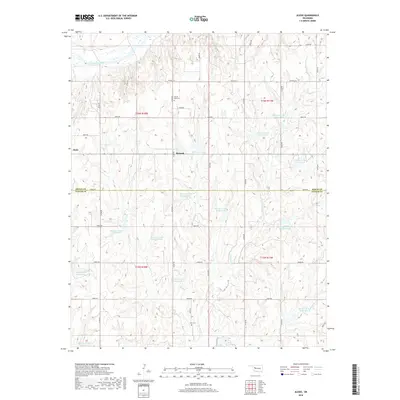
2018 Map of Aledo
USGS Topo · Published 2018About this map
Aledo and Burmah anchor this agricultural landscape on the border of Dewey and Custer counties. The Canadian River cuts across the northern edge of the terrain, while the complex drainage of E Barnitz Cr defines the central and southern reaches. A notable feature of this rural region is the dense network of flood control structures, represented by numerous numbered sites such as Barnitz Cr Site 11 Reservoir and Barnitz Cr Site 13 Reservoir. These reservoirs, including the larger Roy Higgins Reservoir, point to significant land management and water conservation efforts in this part of Oklahoma. For those researching local history or genealogy, the map identifies family-named and community landmarks like Prairie Bell Cem and Elm Cem, situated among the section-line roads that divide the township into a strictly regulated grid.
Find a feature on this map
42 named features on this map. Tap any name to fly to it.
Don’t see what you’re looking for? This feature index may not catch every label — zoom into the map to look around manually.
Map Details
Editions of this 2018 Aledo Map
This is the sole edition of this map. No revisions or reprints were ever made.
Other maps of this area

1955 · Clinton
USGS Topo · 1:250,000

1957 · Clinton
USGS Topo · 1:250,000

1957 · Butler
USGS Topo · 1:62,500

1957 · Clinton
USGS Topo · 1:62,500

1962 · Putnam
USGS Topo · 1:62,500

1962 · Aledo
USGS Topo · 1:62,500

1976 · Butler NW
USGS Topo · 1:24,000

1976 · Butler NE
USGS Topo · 1:24,000

1976 · Clinton NW
USGS Topo · 1:24,000
1983 · Custer City
USGS Topo · 1:24,000