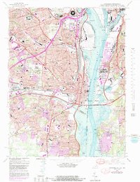
1965 Map of Alexandria
USGS Topo · Published 1989About this map
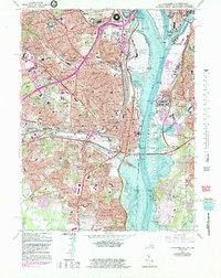
The Potomac River corridor serves as the central artery for this densely developed region, where the monumental architecture of the Department of Defense (Pentagon) and the busy tarmac of Washington National Airport dominate the riverbank. This mid-1960s survey illustrates a period of intense suburban consolidation across Arlington County and Alexandria City, showing the expansion of neighborhoods like Arlington Village and Beverley Hills. The logistical importance of the area is anchored by the sprawling Potomac Yards and the junction of the Southern and Richmond Fredericksburg and Potomac railroads. On the eastern shore, federal and military presence remains significant at Bolling Air Force Base and the U S Naval Research Laboratory. Amidst this growth, older institutions such as the Virginia Theological Seminary and Arlington National Cemetery provide a sense of established permanence.
Find a feature on this map
207 named features on this map. Tap any name to fly to it.
Don’t see what you’re looking for? This feature index may not catch every label — zoom into the map to look around manually.
Map Details
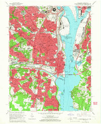
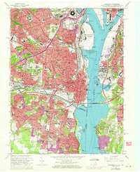
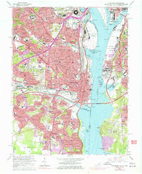
Editions of this 1965 Alexandria Map
6 editions found

Other maps of this area

1890 · Mt. Vernon
USGS Topo · 1:125,000

1891 · Mt. Vernon
USGS Topo · 1:125,000

1892 · Brandywine
USGS Topo · 1:62,500

1894 · Mt. Vernon
USGS Topo · 1:125,000

1895 · Brandywine
USGS Topo · 1:62,500

1897 · Mt. Vernon
USGS Topo · 1:125,000

1899 · Patuxent
USGS Topo · 1:125,000

1900 · Washington
USGS Topo · 1:62,500

1906 · Patuxent
USGS Topo · 1:125,000

1911 · Brandywine
USGS Topo · 1:62,500