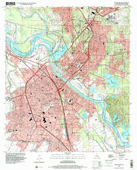
1998 Map of Alexandria
USGS Topo · Published 2001About this map
The Red River corridor defines the dual growth of these central Louisiana sister cities, where extensive levee systems and the Diversion Channel manage the surrounding wetlands. In Pineville, a cluster of major institutions including the Central Louisiana State Hospital, VA Hospital, and Camp Beauregard characterize the landscape northeast of the river. The survey captures the dense urban grid of Alexandria, revealing a specialized infrastructure of industrial sites like the Alexandria Junction Mill and transportation hubs like Pineville Junction.
Find a feature on this map
82 named features on this map. Tap any name to fly to it.
Don’t see what you’re looking for? This feature index may not catch every label — zoom into the map to look around manually.
Map Details
Editions of this 1998 Alexandria Map
This is the sole edition of this map. No revisions or reprints were ever made.
Other maps of this area

1932 · Boyce NE
USGS Topo · 1:31,680

1935 · Lecompte
USGS Topo · 1:62,500

1941 · Alexandria
USGS Topo · 1:62,500

1941 · Boyce
USGS Topo · 1:62,500

1945 · Boyce SE
USGS Topo · 1:31,680

1949 · Boyce SE
USGS Topo · 1:31,680

1953 · Alexandria
USGS Topo · 1:250,000

1955 · Alexandria
USGS Topo · 1:250,000

1956 · Forest Hill
USGS Topo · 1:62,500

1956 · Boyce
USGS Topo · 1:62,500