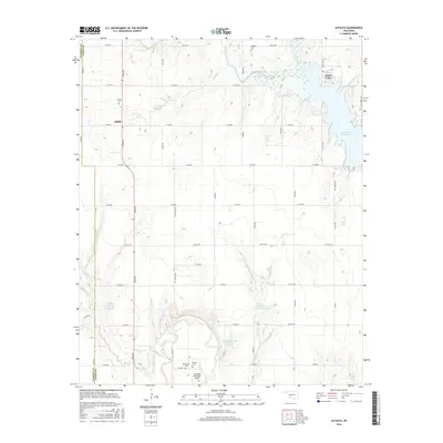
2016 Map of Alfalfa
USGS Topo · Published 2016About this map
The Washita River and its varied tributaries, including Running Cr and Cobb Creek, define the landscape of this Oklahoma quadrangle. In the northern reaches, the community of Alfalfa sits near the Alfalfa Cem, reflecting a long-established rural settlement pattern typical of Caddo County. The northeastern corner is dominated by the sprawling waters of the Fort Cobb Reservoir and the distinct smaller basin of Swan Lake. This modern survey illustrates the intersection of water management and agriculture, shown through multiple impoundments like Cowden Laterals Site 101 Reservoir. For genealogists and local historians, the map's value is enhanced by several named burial sites, including Radford Cem and Daugamah Cem, situated near the Carnegie Municipal Airport. The survey also marks the political boundary where Washita County meets Caddo County, following the western edge of the township grid.
Find a feature on this map
50 named features on this map. Tap any name to fly to it.
Don’t see what you’re looking for? This feature index may not catch every label — zoom into the map to look around manually.
Map Details
Editions of this 2016 Alfalfa Map
This is the sole edition of this map. No revisions or reprints were ever made.
Other maps of this area

1951 · Binger
USGS Topo · 1:62,500

1951 · Fort Cobb
USGS Topo · 1:62,500

1955 · Clinton
USGS Topo · 1:250,000

1957 · Clinton
USGS Topo · 1:250,000

1961 · Eakly
USGS Topo · 1:62,500

1961 · Carnegie
USGS Topo · 1:62,500

1979 · Sickles
USGS Topo · 1:24,000
1979 · Fort Cobb Dam
USGS Topo · 1:24,000
1979 · Fort Cobb
USGS Topo · 1:24,000

1984 · Eakly
USGS Topo · 1:24,000