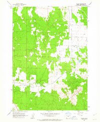
1962 Map of Alfalfa
USGS Topo · Published 1963About this map
The small community of Alfalfa serves as the focal point of this Deschutes County survey, captured just as the local landscape was shaped by irrigation and early road development. The presence of the Grange Hall highlights the area's agricultural identity, while the Central Oregon Canal underscores the engineering efforts required to bring water to this high desert environment. To the southeast, the terrain shifts abruptly into the Badlands, where the natural topography contrasts with the rectilinear grid of family-named thoroughfares such as Horsell Road, Schmidt Road, and Abernathy Rd. These routes provide a detailed look at the 1960s settlement patterns and the division of land across the high plateau. The map also traces the ephemeral course of Dry River and identifies local landmarks like Zell Pond, documenting the specific water resources essential to the region's mid-century residents.
Find a feature on this map
17 named features on this map. Tap any name to fly to it.
Don’t see what you’re looking for? This feature index may not catch every label — zoom into the map to look around manually.
Map Details
Editions of this 1962 Alfalfa Map
2 editions found
Other maps of this area

1926 · Bend
USGS Topo · 1:125,000

1929 · Bend
USGS Topo · 1:125,000

1931 · Newberry Crater
USGS Topo · 1:125,000

1935 · Newberry Crater
USGS Topo · 1:125,000

1955 · Crescent
USGS Topo · 1:250,000

1955 · Bend
USGS Topo · 1:250,000

1957 · Crescent
USGS Topo · 1:250,000

1957 · Bend
USGS Topo · 1:250,000

1958 · Crescent
USGS Topo · 1:250,000

1958 · Bend
USGS Topo · 1:250,000