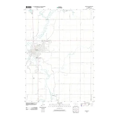
2010 Map of Algona
USGS Topo · Published 2010About this map
The East Fork Des Moines River winds through the heart of this landscape, its serpentine path defining the character of Algona and the surrounding prairie. This area serves as a key agricultural and civic hub for the county, anchored by the Kossuth County Fairgrounds and the central Algona Post Office. The town's development is closely tied to the river's geography, with River View Cemetery and East Lawn Cemetery situated on elevated ground overlooking the water.
Find a feature on this map
34 named features on this map. Tap any name to fly to it.
Don’t see what you’re looking for? This feature index may not catch every label — zoom into the map to look around manually.
Map Details
Editions of this 2010 Algona Map
This is the sole edition of this map. No revisions or reprints were ever made.
Other maps of this area

1954 · Fairmont
USGS Topo · 1:250,000

1954 · Fort Dodge
USGS Topo · 1:250,000

1957 · Fort Dodge
USGS Topo · 1:250,000

1958 · Fort Dodge
USGS Topo · 1:250,000

1958 · Fairmont
USGS Topo · 1:250,000

1972 · Algona
USGS Topo · 1:24,000

1972 · St. Joseph
USGS Topo · 1:24,000

1972 · Titonka
USGS Topo · 1:24,000

1972 · Burt
USGS Topo · 1:24,000
1972 · Sexton
USGS Topo · 1:24,000