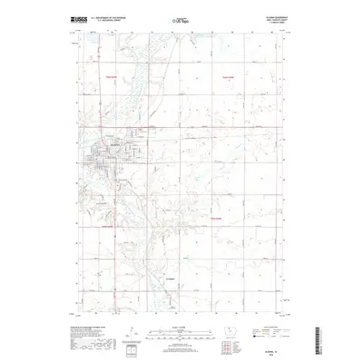
2018 Map of Algona
USGS Topo · Published 2018About this map
Algona serves as the regional anchor for this north-central Iowa landscape, situated where the East Fork Des Moines River winds southward toward the smaller settlement of Irvington. The town’s grid is well-defined by a dense network of residential streets such as E State St and W Call St, while the surrounding terrain is dominated by agricultural sections and significant water features including Black Cat Creek and Oak Lake. This 2018 survey reveals a community deeply rooted in its local history, evidenced by the numerous burial grounds documented across the quadrangle, from River View Cem and Calvary Cem on the northern edge of town to Laurel Hill Cem near the southern boundary. The inclusion of Hungry Hollow Rd suggests the varied topography that breaks the predominantly flat plains typical of Kossuth County.
Find a feature on this map
49 named features on this map. Tap any name to fly to it.
Don’t see what you’re looking for? This feature index may not catch every label — zoom into the map to look around manually.
Map Details
Editions of this 2018 Algona Map
This is the sole edition of this map. No revisions or reprints were ever made.
Other maps of this area

1954 · Fairmont
USGS Topo · 1:250,000

1954 · Fort Dodge
USGS Topo · 1:250,000

1957 · Fort Dodge
USGS Topo · 1:250,000

1958 · Fort Dodge
USGS Topo · 1:250,000

1958 · Fairmont
USGS Topo · 1:250,000

1972 · Algona
USGS Topo · 1:24,000

1972 · St. Joseph
USGS Topo · 1:24,000

1972 · Titonka
USGS Topo · 1:24,000

1972 · Burt
USGS Topo · 1:24,000
1972 · Sexton
USGS Topo · 1:24,000