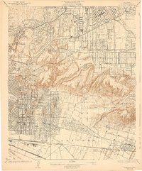
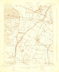
1926 Map of Alhambra
USGS Topo · Published 1939About this map
Alhambra and its neighboring eastern Los Angeles suburbs appear here during a period of rapid residential and industrial expansion in the mid-1920s. The landscape is a transition between the dense urban grid of East Los Angeles and the hills of La Merced, marked by a complex network of transportation. The Pacific Electric and Southern Pacific rail lines cut through growing tracts like Belvedere Gardens and Winter Gardens, while the iconic San Gabriel Mission anchors the northeastern corner. This survey documents the area's early 20th-century character, from the Ascot Speedway near Omaha Heights to the emerging petroleum infrastructure at the Montebello Standard Oil Co. Significant genealogical landmarks are meticulously detailed, including the expansive Evergreen Cemetery and New Calvary Cemetery, alongside early educational sites like the Granada School.
Find a feature on this map
54 named features on this map. Tap any name to fly to it.
Don’t see what you’re looking for? This feature index may not catch every label — zoom into the map to look around manually.
Map Details
Editions of this 1926 Alhambra Map
4 editions found
Other maps of this area

1894 · Los Angeles
USGS Topo · 1:62,500

1896 · Pasadena
USGS Topo · 1:62,500

1896 · Downey
USGS Topo · 1:62,500

1899 · Downey
USGS Topo · 1:62,500

1900 · Pasadena
USGS Topo · 1:62,500

1900 · Los Angeles
USGS Topo · 1:62,500

1901 · Southern California Sheet No. 1
USGS Topo · 1:250,000

1902 · Downey
USGS Topo · 1:62,500

1904 · Southern California Sheet No. 1
USGS Topo · 1:250,000
1923 · Bell
USGS Topo · 1:24,000