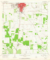
1963 Map of Alice South
USGS Topo · Published 1964About this map
The hub of Alice dominates the landscape of the Coastal Bend in the early 1960s, appearing here as a busy intersection of petroleum production and transportation. The Southern Pacific railroad runs north-to-south through the center of town, flanked by local landmarks such as the Nayer Sch, Salazar Sch, and St Joseph Sch. Beyond the residential blocks, the land is defined by extensive energy infrastructure, including the Alice Oil Field, the Magnolia City Oil Field, and the Borregas Oil Field. Local families and genealogists will find several community markers, from the Fraternal Cem to the smaller settlement of Ben Bolt in the south. The rural landscape is cut by the winding paths of Lattas Creek and San Andres Creek, providing a stark contrast to the rigid grid of pipelines and farm roads like Farm Road 1554 that service the region's industry.
Find a feature on this map
30 named features on this map. Tap any name to fly to it.
Don’t see what you’re looking for? This feature index may not catch every label — zoom into the map to look around manually.
Map Details
Editions of this 1963 Alice South Map
This is the sole edition of this map. No revisions or reprints were ever made.
Other maps of this area

1917 · Ben Bolt
USGS Topo · 1:62,500

1920 · San Diego
USGS Topo · 1:62,500

1950 · Corpus Christi
USGS Topo · 1:250,000

1954 · Orange Grove
USGS Topo · 1:62,500

1954 · Kingsville
USGS Topo · 1:62,500

1956 · Corpus Christi
USGS Topo · 1:250,000

1956 · Laredo
USGS Topo · 1:250,000

1960 · Corpus Christi
USGS Topo · 1:250,000

1963 · Ben Bolt SE
USGS Topo · 1:24,000

1963 · San Diego
USGS Topo · 1:24,000