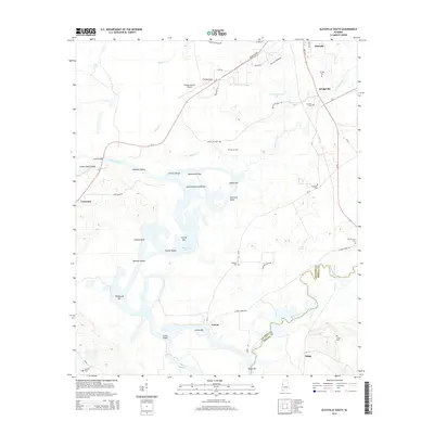
2014 Map of Aliceville South
USGS Topo · Published 2014About this map
Tombigbee River navigation and the riverine borderlands of western Alabama define this landscape south of Aliceville. The intricate waterway is marked by a series of historic shoals and bars, such as Hancock Shoals and Summerville Bar, reflecting a time when river pilots carefully navigated around Streets Island and the Summerville Cutoff Bar. The interior is dotted with small rural communities and family burial grounds, including Bridgeville and the Trantham Cem. In the south, the Sipsey River forms the boundary between Pickens and Greene counties. This survey preserves the locations of established landmarks like the George Downer Airport and the settlement of Cochrane near the riverbanks, alongside the low-lying waters of Gainesville Lake.
Find a feature on this map
63 named features on this map. Tap any name to fly to it.
Don’t see what you’re looking for? This feature index may not catch every label — zoom into the map to look around manually.
Map Details
Editions of this 2014 Aliceville South Map
This is the sole edition of this map. No revisions or reprints were ever made.
Other maps of this area

1953 · Meridian
USGS Topo · 1:250,000

1953 · West Point
USGS Topo · 1:250,000

1957 · Meridian
USGS Topo · 1:250,000

1958 · West Point
USGS Topo · 1:250,000

1963 · West Point
USGS Topo · 1:250,000

1965 · Meridian
USGS Topo · 1:250,000

1970 · Aliceville North
USGS Topo · 1:24,000
1970 · Cunningham
USGS Topo · 1:24,000
1970 · Pleasant Ridge
USGS Topo · 1:24,000
1970 · West Greene
USGS Topo · 1:24,000