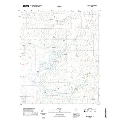
2020 Map of Aliceville South
USGS Topo · Published 2020About this map
Aliceville and the southern reaches of its surrounding countryside are defined by the winding course of the Tombigbee River, where modern water management via the Tennessee-Tombigbee Waterway meets the older, looping hydrology of the Dead River and Gainesville Lake. This riverine landscape is punctuated by numerous named bars and shoals, such as Summerville Bar and Hancock Shoals, indicating the historical challenges of navigating these shifting waters.
Find a feature on this map
66 named features on this map. Tap any name to fly to it.
Don’t see what you’re looking for? This feature index may not catch every label — zoom into the map to look around manually.
Map Details
Editions of this 2020 Aliceville South Map
This is the sole edition of this map. No revisions or reprints were ever made.
Other maps of this area

1953 · Meridian
USGS Topo · 1:250,000

1953 · West Point
USGS Topo · 1:250,000

1957 · Meridian
USGS Topo · 1:250,000

1958 · West Point
USGS Topo · 1:250,000

1963 · West Point
USGS Topo · 1:250,000

1965 · Meridian
USGS Topo · 1:250,000

1970 · Aliceville North
USGS Topo · 1:24,000
1970 · Cunningham
USGS Topo · 1:24,000
1970 · Pleasant Ridge
USGS Topo · 1:24,000
1970 · West Greene
USGS Topo · 1:24,000